


Voting District 130002, Broome County, New York
About
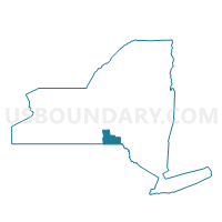
Outline

Summary
| Unique Area Identifier | 625631 |
| Name | Voting District 130002 |
| County | Broome County |
| State | New York |
| Area (square miles) | 44.29 |
| Land Area (square miles) | 43.69 |
| Water Area (square miles) | 0.60 |
| % of Land Area | 98.64 |
| % of Water Area | 1.36 |
| Latitude of the Internal Point | 42.06841620 |
| Longtitude of the Internal Point | -75.52025010 |
Maps


Graphs
Select a template below for downloading or customizing gragh for Voting District 130002, Broome County, New York


Neighbors
Neighoring Voting District (by Name) Neighboring Voting District on the Map
- Voting District 050003, Broome County, NY
- Voting District 130001, Broome County, NY
- Voting District 130003, Broome County, NY
- Voting District 170001, Broome County, NY
- HARMONY TWP Voting District, Susquehanna County, PA
- SCOTT TWP Voting District, Wayne County, PA
Top 10 Neighboring County Subdivision (by Population) Neighboring County Subdivision on the Map
- Windsor town, Broome County, NY (6,274)
- Colesville town, Broome County, NY (5,232)
- Sanford town, Broome County, NY (2,407)
- Scott township, Wayne County, PA (593)
- Harmony township, Susquehanna County, PA (528)
Top 10 Neighboring Place (by Population) Neighboring Place on the Map
Top 10 Neighboring Unified School District (by Population) Neighboring Unified School District on the Map
- Wayne Highlands School District, PA (20,842)
- Windsor Central School District, NY (10,775)
- Susquehanna Community School District, PA (5,302)
- Harpursville Central School District, NY (5,268)
- Afton Central School District, NY (3,974)
- Deposit Central School District, NY (3,888)
Top 10 Neighboring State Legislative District Lower Chamber (by Population) Neighboring State Legislative District Lower Chamber on the Map
Top 10 Neighboring State Legislative District Upper Chamber (by Population) Neighboring State Legislative District Upper Chamber on the Map
Top 10 Neighboring 111th Congressional District (by Population) Neighboring 111th Congressional District on the Map
- Congressional District 22, NY (679,297)
- Congressional District 10, PA (669,257)
- Congressional District 24, NY (657,222)
Top 10 Neighboring Census Tract (by Population) Neighboring Census Tract on the Map
- Census Tract 125, Broome County, NY (6,274)
- Census Tract 123, Broome County, NY (5,232)
- Census Tract 323, Susquehanna County, PA (3,857)
- Census Tract 9602, Wayne County, PA (3,137)
- Census Tract 124, Broome County, NY (2,407)